Ingest the World
A geospatial data platform where the database decides who sees what.
The problem
Teams that work with geospatial data receive files of every shape: a few bytes of sensor readings, multi-gigabyte rasters and point clouds, 3D models too big to open casually. Each one has to land in the right store, be described well enough to find again, and be visible only to people cleared to see it, on commercial Azure and on Azure Government alike.
What I built
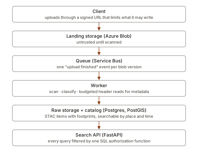
A client asks for an upload and gets a signed URL that limits what it may write. When the file lands, an event goes on a queue. A worker scans it, works out what kind of file it is, reads only as much of its header as it needs to extract metadata, promotes it to raw storage and catalogs it as a STAC item in Postgres with PostGIS. A FastAPI service serves search and item reads to a React app that signs in with OIDC.
Key decisions
- The database decides who sees what. One SQL function works out which collections a user may read from their roles and clearance. Every query filters through it, and the Python code never re-implements the rule. Every catalog access writes one audit event before responding.
- Guarantees are written down and tested. Properties like “no leaks”, “every access is audited” and “processing an event twice changes nothing” are numbered invariants. Hypothesis state machines drive the real API and Postgres with random users and operations, checking the invariants after every step. The pipeline simulator runs the worker over a queue and blob store that drop, duplicate and fail, then replays every event.
- Fakes are held to the real thing. Each external dependency has one behavioural test suite that runs against both the seeded fake and the real emulator (Azurite, the Service Bus emulator), so the fakes can’t drift from reality.
- The tests are tested. Mutation testing plants known bugs and checks that the right invariant catches each one.
- One deployment for two clouds. A single Terraform module targets commercial Azure or Azure Government with one variable. Sign-in is provider-neutral OIDC: Keycloak locally, Entra ID in the cloud.
What I’d do next
- Finish the derive stage, which turns each original into web-ready copies, each rendered in an isolated process: Cloud-Optimized GeoTIFFs and thumbnails for rasters (under way now), then GeoParquet for vector data, COPC for point clouds and 3D Tiles for meshes.
- Serve those copies safely: downloads and thumbnails through short-lived, access-checked links, and map tiles from a tile server that applies the same access rules as search.
- Make the map live, with footprints as vector tiles, raster previews and processing status pushed to the browser. After that, a 3D viewer that places models on the map.